Wednesday, April 16, 2014

Mummified by accident in copper masks almost 1,000 years ago: but who were they?

Academics restart work to unlock secrets of mystery medieval civilization with links to Persia on edge of the Siberian Arctic.

The 34 shallow graves excavated by archeologists at Zeleniy Yar throw up many more questions than answers. But one thing seems clear: this remote spot, 29 km shy of the Arctic Circle, was a trading crossroads of some importance around one millennium ago. 
The medieval necropolis include 11 bodies with shattered or missing skulls, and smashed skeletons. Five mummies were found to be shrouded in copper, while also elaborately covered in reindeer, beaver, wolverine or bear fur. Among the graves is just one female, a child, her face masked by copper plates. There are no adult women.  
Nearby were found three copper masked infant mummies - all males. They were bound in four or five copper hoops, several centimeters wide.
Similarly, a red-haired man was found, protected from chest to foot by copper plating. In his resting place, was an iron hatchet, furs, and a head buckle made of bronze depicting a bear.
The feet of the deceased are all pointing towards the Gorny Poluy River, a fact which is seen as having religious significance. The burial rituals are unknown to experts.

Artifacts included bronze bowls originating in Persia, some 3,700 miles to the south-west, dating from the tenth or eleventh centuries. One of the burials dates to 1282, according to a study of tree rings, while others are believed to be older. 
The researchers found by one of the adult mummies an iron combat knife, silver medallion and a bronze bird figurine. These are understood to date from the seventh to the ninth centuries. 
Unlike other burial sites in Siberia, for example in the permafrost of the Altai Mountains, or those of the Egyptian pharaohs, the purpose did not seem to be to mummify the remains, hence the claim that their preservation until modern times was an accident.
The soil in this spot is sandy and not permanently frozen.A combination of the use of copper, which prevented oxidation, and a sinking of the temperature in the 14th century, is behind the good condition of the remains today. 

Natalia Fyodorova, of the Ural branch of the Russian Academy of Sciences, said: 'Nowhere in the world are there so many mummified remains found outside the permafrost or the marshes. 
'It is a unique archaeological site. We are pioneers in everything from taking away the object of sandy soil (which has not been done previously) and ending with the possibility of further research.'
In 2002, archeologists were forced to halt work at the site due to objections by locals on the Yamal peninsula, a land of reindeer and energy riches known to locals as 'the end of the earth'.
The experts were disturbing the souls of their ancestors, they feared. However, work is underway again, including a genetic study of the remains headed by Alexander Pilipenko, research fellow of Institute of Cytology and Genetics, Siberian Branch of the Russian Academy of Sciences. 

Fyodorova suggests that the smashing of the skulls may have been done soon after death 'to render protection from mysterious spells believed to emanate from the deceased'.
With work underway again, archeologists hope for clearer answers. 

Source: The Siberian Times

Tuesday, April 15, 2014

Qanat Firaun, the most spectacular underground aqueduct of the ancient world


The Qanat Firaun, otherwise known as the Gadara Aqueduct, is an ancient aqueduct that was built to supply water to the Roman-Hellenistic Decapolis, which now lie in present-day Syria and Jordan.  Although the Arabic name ‘Qanat Firaun’ means ‘Canal of the Pharaohs’, the massive canal was not Egyptian but Imperial Roman, and stands as a testament to their incredible engineering abilities. The 170-kilometre pipeline is not only the world’s longest underground aqueduct of the antiquity, it is also the most complex, and represents a colossal work of hydroengineering. 

The Decapolis was a group of ten cities on the eastern frontier of the Roman Empire, which were grouped together because of their language, culture, location, and political status, with each possessing a certain degree of autonomy and self-rule. Its capital, Gadara, was home to more than 50,000 people and became distinguished for its cosmopolitan atmosphere, its own 'university' with scholars, attracting writers, artists, philosophers and poets. But something was missing in this wealthy city – an abundance of water.

The Gadara Aqueduct changed all that. “In the capital alone there were thousands of fountains, drinking troughs and thermal baths. Rich senators refreshed themselves in private pools and decorated their gardens with cooling grottos. The result was a record daily consumption of over 500 litres of water per capita,” said Matthias Schulz, author of a report about the aqueduct in Spiegel Online. 

The underground canal system was rediscovered by Mathias Döring, a hydromechanics professor in Darmstadt, Germany, in 2004. Excavations revealed that the pipelines were constructed with an average height of 2.5 metres and a width of 1.5 metres. The aqueduct extended for 64 kilometres on the surface, before disappearing underground into three separate tunnels, with lengths of 1, 11, and 94 kilometres. The longest previously known underground water channel of the ancient world, in Bologna, is 19 kilometres long, so the discovery of the Gadara Aqueduct, and the sheer scale of the construction, was met with both shock and awe. 
Plan of the upper and lower tunnel system under the acropolis of Gadara.
The massive construction effort began in around 90 AD and continued relentlessly for the following 120 years. It started above ground in Syria, where they made rapid progress. However, as they entered Jordan, the workers and engineers were met with enormous obstacles, the first of which was a 200-metre chasm. They attempted to build around it but the rough terrain made it impossible to continue over the surface, so they carved an underground channel through a rocky mountain, which continued for 11 kilometres.
Beyond this, they were faced with an endless succession of hills and steep slopes and, if they were to continue underground, they needed to find a way to provide adequate ventilation inside the tunnels. To overcome this problem, they built sloping shafts into the rock every 20 to 200 metres. These provided fresh air and enabled hundreds of men to work simultaneously in different sections of the tunnel. More than 300 access tunnels leading down to the main canal have been found so far.
An outline of the Gadara Aqueduct’s construction. Photo Credit: Der Spiegal
The construction of the aqueduct demonstrates remarkable precision. The gradient of the tunnel was found to be 0.3 per thousand, meaning that it dropped only 30 centimetres per kilometre – an amazingly shallow angle of decent. Along the main road of Gadara, archaeologists found basal pressure piles which suggested a siphon structure in order to supply the western outskirts of the city with fresh water, supposedly from sources 100 kilometres away. By the time work ceased on the aqueduct, workers had excavated over 600,000 cubic metres of limestone, comparable to more than a full quarter of the Great Pyramid’s total volume.

However, despite this remarkable feat of engineering, the Garadar Aqueduct was never fully completed and was put into service only in sections. The original plan called for the water to fill a high stone reservoir that would feed the city's fountains and the planned temple to the nymphs. But that never happened. The surveyors ended up making a number of miscalculations and the water - after over 170 kilometers - arrived in Gadara slightly too low for the grand plans. As Mr Schulz explains, “nothing created by the hand of man is ever perfect”.


Source: AO

Monday, April 14, 2014

A Treasure Trove of Historic Maps

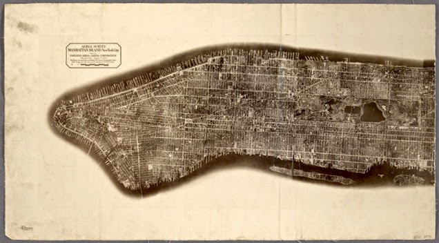
The New York Public Library scanned a huge number of maps. The maps are released under aCreative Commons license, so they're in the public domain for you to study, modify, and modify, or whatever other cartographic desire your little heart holds.

A chart of the West Indies from Cape Cod to River Oronoque.


Aerial survey, Manhattan Island, New York City


Virginia


I love the colour-highlights marking edges, and the explicit reminder that the United States was not colonized exclusively by English-speaking settlers. Full map.

Glen Haven Water Cure & Summer Resort


The full title is, "No.1 Hotel., No.2 Bath Houses., No.3 Cottages to Rent., No.4 Boat Houses & Dance Hall., No.5 Billiard Room. Glen Haven Water Cure & Summer Resort, Situated at the Head of Skaneatles Lake, Glen Haven, Cortland Co. N.Y." This mouthful of a sketch is from the county atlas of Cayuga, New York. My favourite part may actually be the subtitle in the filing system, "From recent and actual surveys and records under the superintendence of F. W. Beers." 1875 is totally recent! Full map.

Castle Rock or Point of Rocks, Bennington Vt.


Another map from the same F.W. Beers collection has a far more reasonable full title, merely spilling out as "Castle Rock or Point of Rocks, Bennington Vt.; View on the Susquehanna.; Descent into the Valley of Wyoming Pa.; View from GlenMary Lawn on the Owego." This one is from the county atlas of Chemung, New York. Full map.

Plan of Sea Gate, New York Harbor Coney Island.


Filed under Brooklyn. Green covers on primary sources always make me feel like the document is the real-deal. Full map.

A plan of the city of Philadelphia and environs


Filed under Philadelphia, of course. From surveys by John Hills "in the summers of 1801, 2, 3, 4, 5, 6 & 7" because listing that as 1801-1807 makes it look too short. Full map.

Terra Nova


Another extremely long full title, "Terra nova, ac maris tractus circa Novam Franciam, Angliam, Belgium, Venezuelam Novam, Andalusiam, Guianan, et Brasiliam / L. Renard : Terra neuf, en de custen van Nieu Vranckryck, Nieu Engeland, Nieu Nederland, Nieu Andalusia, Guiana en Venezuela." Full map.

Map of North America


And finally, a map of North America, as "drawn and engraved" by D'Anville "under the Patronage of Duke of New Orleans" and published for J. Harrison, London, January 1791. Full map.
This is but the tiniest sampling of the newly-released collection, so go! Shoo! Browse the mapsand bring me back your treasures.
Maps from The Lionel Pincus & Princess Firyal Map Division, The New York Public Library, a collection of awesome people for setting these high-resolution scans into the wild.

Source: io9

Friday, April 11, 2014

Scientists say papyrus referring to wife of Jesus is no fake


In September, 2012, a faded fragment of papyrus, which has controversially come to be known as 'The Gospel of Jesus’s Wife', made international headlines when it was unveilled by Harvard Divinity School historian Karen L. King.  The announcement, unsurprisingly, was met with both anger and elation, as well as a great deal of skepticism as it contained a phrase never seen before in any other scripture: "Jesus said to them, my wife….", and "she will be able to be my disciple", a phrase that stirred debate over whether women should be allowed to be priests.  An editorial in the Vatican’s newspaper declared that the papyrus was a fake, as did a number of other scholars. However, the fragment has now been thoroughly tested by scientists who conclude, in a report published in the Harvard Theological Review, that the ink (actually pigment) and papyrus have ancient origins, and the fragment is not, therefore, a modern forgery.


The papyrus fragment has now been tested by scientists at Columbia University, Harvard University, and the Massachusetts Institute of Technology (M.I.T.), who carried out carbon-dating as well as micro-Raman spectroscopy to determine the chemical composition of the ink. The results revealed that: the papyrus can be dated to approximately 700 to 800 AD, it is consistent with other papyri from the fourth to the eight centuries, the carbon black ink (actually a type of pigment) was typical of that used on other papyri of the time, and the text did not show any variations or inconsistencies which would suggest doctoring. 

The text is written in Sahidic, a language of ancient Egypt, and the study authors have suggested that it may be a transcription of an earlier Coptic text that was based on a Greek copy made centuries earlier, as many early Christian gospels are. Therefore, a date of 700 to 800 AD does not mean that this was the first time the text appeared.

However, scientific analysis is not always enough to convince some. The Harvard Theological review, is also publishing a counter piece by Egyptologist at Brown University, Leo Depuydt, whose paper predates the scientific analysis. According to a report on the story in the New York Times, Dr Depuydt said that testing the fragment was irrelevant and he saw “no need to inspect it”. He said he decided that it is a fake based on a newspaper photograph of the papyrus in which he saw “grammatical errors”, as well as similarity to writing in the Gospel of Thomas. In a rebuttal, King finds Depuydt’s textual analysis unpersuasive.

Dr King has been quick to point out that the test results do not prove that Jesus had a wife or disciples who were women, only that the fragment is ancient rather than forged. She does hope, however, that the discussion, commentary, and focus can now move on from ‘is it fake?’ to ‘what does all this mean?


Source: AO

Thursday, April 10, 2014

Surprise finding as ancient Egyptian sarcophagus is found in Israel

Archaeologists made a rare and unexpected discovery during a natural gas pipeline salvage excavation in Jezereel Valley, Israel, when they came across a 3,300-year-old Egyptian sarcophagus complete with human remains and numerous grave goods. It is the first time in around fifty years that an anthropoidal (person-shaped) coffin has been found in present-day Israel.
The Bronze Age clay coffin contained an anthropoidal lid with a naturalistic impression of a man’s face, with stylized hair in an Egyptian style, ears and, like sarcophagi of Egyptian pharaohs, hands crossed over the chest in the manner of the deceased. The clay coffin was surrounded by pottery, storage vessels, and animal bones. Inside the sarcophagus was an adult skeleton, pottery, a bronze dagger, a bronze bowl, hammered pieces of bronze and, most significantly, a rare Egyptian scarab seal of Pharaoh Seti I encased in gold and affixed to a ring. The seal features the winged Uraeus (cobra), protector of the pharaoh’s name and person. 
The gold scarab seal. Photo credit: Clara Amit, courtesy of the Israel Antiquities Authority

Pharaoh Seti I ruled Egypt from around 1290 to 1279 BC and is considered by many Egyptologists to be one of the most powerful kings of the 19th Dynasty. In the first year of his reign, Seti I put down a revolt in the Bet Shean Valley, which is located not far from where the coffin was found. After conquering the region, the pharaoh established Egyptian rule in Canaan and instated Canaanite vassals to rule the territory on the pharaoh’s behalf.  Canaan roughly corresponds to the Levant, i.e. modern-day Lebanon, Israel, Palestinian territories, the western part of Jordan and south-western Syria. 

Archaeologists are not entirely clear who the coffin belonged to, but IAA excavation director Dr. Ron Be’eri suggests that the remains may belong to a wealthy Canaanite rather than Egyptian. Egyptians traditionally buried their dead in Egyptian soil, and the grave goods were distinctly Canaanite. The graves of two men and two women, who may have been members of his family, were found buried nearby in a similar style.  The deceased may have been an official of Canaanite origin who was engaged in the service of the Egyptian government, or a wealthy local who imitated Egyptian customs. However, Be’eri added that Canaanites “were not accustomed to burying themselves in coffins of this sort. The Canaanite style of burial is different.” 
The Egyptian coffin from Jezreel Valley. Photo credit: Dan Kirzner, courtesy of the Israel Antiquities Authority

The IAA is currently considering sampling the DNA from inside the coffin to see if the deceased was originally a Canaanite, or an Egyptian buried in Canaan. 

Source: AO

Wednesday, April 9, 2014

Ancient manuscript returns home to Greek monastery on Mount Athos


The Getty Museum is returning a 12th century illuminated New Testament to the Monastery of Dionysiou on Greece's Mount Athos after it came to light that it had been illegally removed from the monastery more than 50 years ago.

The treasured manuscript is currently being displayed at the Getty Center in Brentwood as part of the exhibition "Heaven and Earth: Byzantine Illumination at the Cultural Crossroad" and will be returned at its conclusion in June. The exhibition features ancient texts and works of art belonging to the Byzantine Empire (330 – 1453 AD), which was greatly admired for its courtly splendour and rich visual arts. Inspired by the legacy of Greco–Roman antiquity, Byzantine manuscript painters in Greece and Asia Minor are noted for their prominent use of gold, a striking sense of naturalism, and a distinctive spiritual character.

Officials at Getty said that the museum acquired the manuscript in 1983 as part of a "large, well-documented" collection and were unaware of its illegal status. However, during research into the manuscript conducted alongside the Hellenic Ministry of Culture and Sports, a 1960 monastery record was discovered, which indicated that the book had been illegally removed.

"Based on new information that came to light through this process, the museum decided that the right course of action was to return the manuscript to the Holy Monastery of Dionysiou from which it disappeared over 50 years ago," said Timothy Potts, director of Getty Museum. 

The Dionysiou Monastery,

Founded in the fourteenth century by St. Dionysios of Koreseos, the Dionysiou Monastery is one of the twenty monasteries located on the peninsula of Mount Athos in north-eastern Greece.  Mount Athos, also known as “Holy Mountains” is a World Heritage Site and an autonomous polity in the Hellenic Republic. According to legend, Mount Athos was formed when Athos, the name of one of the Gigantes that challenged the Greek gods during the Gigantomachia, threw a massive rock against Poseidon which feel in the Aegean Sea. It is believed that monks have inhabited the island since the 3rd century AD.

Upon its return, the 12th century New Testament will join the well-organised monastery library, which includes 804 codices, more than 5,000 old printed books, and an illuminated Gospel from the 13th century. 


Source: AO

Monday, April 7, 2014

Do the ancient stone walls of Saksaywaman in Peru contain hidden communication?


Lying on the northern outskirts of the city of Cusco in Peru, lies the remarkable walled complex of Saksaywaman (Sacsayhuaman), believed to have been built by the Inca. The site is famous for its remarkable large dry stone walls with boulders carefully cut to fit together tightly without mortar, displaying a precision of fitting that is unmatched in the Americas. This, combined with the variety of interlocking shapes, and the way the walls lean inward has puzzled scientists for decades. But there is another puzzle hidden in the stones of Saksaywaman – the angles of the stones, according to researcher Dr Derek Cunningham, correspond to astronomical alignments.

Dr Cunningham, author of ‘400,000 Years of Stone Age Science’, has put forward a theory that ancient civilizations developed writing from a very archaic geometrical form that is based on the study of the motion of the moon and the sun. According to his hypothesis, astronomical values considered central to the prediction of eclipses, are converted into angular values. In total, there are approximately 9 standard values which Dr Cunningham has identified in a large number of ancient drawings, with a small number of secondary values that are occasionally seen in regional art. Some examples, include the Stonehenge lozenge, the Kharga Oasis Spider, and religious statues from Cyprus.

Now he has discovered the same values are present in the construction of the Saksaywaman stone wall.

The most important of these astronomical values is the sidereal month, which is drawn in early astronomical texts as an angular value at either 13.66 or 27.32 degrees to represent the half and full month values. After the sidereal month value is known it is then a simple matter for astronomers to calculate that the earth is moving approximately 1 degree per day around the sun, and through more careful observations to deduce there is an eclipse season every 6.511 draconic months, this being a time period a time period equivalent to 6 synodic months. Other parameters important for predicting eclipses are the 5.1 degree angle of inclination of the moon’s orbit, and the 9.3/18.6 year lunar nutation cycle. Finally a value of 11 degrees is found on many early Stone Age artefacts, which corresponds to the 11 day difference between the lunar and solar year. 
Arrangement of stones in a wall at Saksaywaman. Astronomical values can be found in the form of an angular array, offset to either above or below the horizontal, or the right or left of the vertical. Photo credit: Derek Cunningham

The astronomical values are also represented in the layout of the walls when viewed from above. 
Astronomical values can be observed in the overhead layout of Saksaywaman. Photo credit: Derek Cunningham 

Despite the theory being developed only recently, to date many sites now show a striking ability to align to the exact same angular values. This includes the causeways located in front of the Great Pyramids of Giza, as well as the lines making up the body of the Atacama Giant. As Dr Cunningham notes, it is impossible to yet verify that the theory is correct, because many images of important artefacts are distorted during uploading to the internet, and satellite images cannot replace direct ground studies, but so far the results are incredibly consistent, and can even be seen in artifacts dating back tens of thousands of years.

“The potential of the idea to explain some things about so many sites from the pyramids of Egypt to the Atacama Giant in Chile is obviously very controversial, and it should be,” said Dr Cunningham in an article on Popular Archaeology. “But if correct, it could rewrite some aspects of our understanding of not only the Stone Age but also world history. If, on the other hand, scholars prove this specific astronomical theory wrong, then we can move on, knowing that it has been sufficiently tested. What is most intriguing is that a complete new window may have been opened into the past." 

Source: AO